
Digital Altimeter Manufacturer,Supplier and Exporter in India
Product Code : EL-ELA-5298
Jlab Export is a leading Digital Altimeter Manufacturer,and suppliers in India
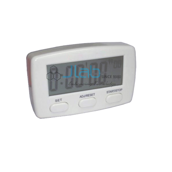
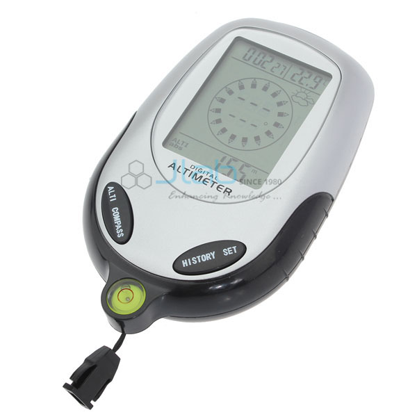
Digital Altimeter (code EL-ELA-5298) is a compact 6-in-1 instrument that shows altitude, air pressure, compass direction, temperature, a weather forecast and the time and date. It reads altitude from −700 m to 9000 m with 1 m resolution, so it suits geography field trips, outdoor science work, hiking, camping and mountaineering. It is made by Jain Laboratory Instruments Pvt Ltd (JLab) at its works in Ambala, India.
Specifications
| Parameter | Detail |
|---|---|
| Functions | 6-in-1: altitude, pressure, direction, temperature, weather forecast, time and date |
| Altimeter range | −700 m to 9000 m (−2296 ft to 29500 ft, as listed) |
| Altitude resolution | 1 m / 3 ft |
| Altitude modes and units | Sea-level altitude or climbing altitude; metres and feet switchable |
| Barometer range | 300 to 1100 hPa |
| Barometer resolution and units | 0.1 hPa; millibar and inHg switchable |
| Thermometer range | −20 to 60 °C (−4 to 140 °F) |
| Thermometer resolution and units | 1 °C / 1 °F; Celsius and Fahrenheit switchable |
| Compass | 360 degrees with 8 directions; 1 degree resolution |
| Weather forecast | 12–24 hours ahead; sunny, slightly sunny, cloudy, rain |
| Time and date | 24-hour or 12-hour format |
| Backlight | LED, 5 seconds |
| Size | Compact |
| Quality check | Each altimeter is visually inspected before dispatch |
| Pack quantity | Each (sold individually) |
| Minimum order quantity | 10 units |
| Dispatch time | Usually 7–10 working days |
| Product code | EL-ELA-5298 |
| Manufacturer | Jain Laboratory Instruments Pvt Ltd (JLab) — OEM |
| Country of origin | India (made in Ambala, Haryana) |
What Is the Digital Altimeter Used For?
A digital altimeter of this kind works out altitude from air pressure, which falls steadily as you climb. That makes it a practical teaching tool: on a geography or environmental science field trip, students can log altitude, pressure and temperature at points along a route and plot how pressure and temperature change with height. The climbing-altitude mode shows how far a group has ascended from its starting point, while the compass gives direction for map work. Hikers, campers and mountaineers use the same functions on the trail, and the forecast symbols, based on the pressure trend, give a 12–24 hour indication of whether weather is settling or turning to cloud and rain.
Because weather systems also change air pressure, a pressure-based altitude reading drifts over hours; set it at a point of known altitude before each outing for the most dependable readings. Keep it away from strong magnets and steel objects when reading the compass, and use the 5-second backlight for readings in poor light.
What to Specify When Ordering
- Quantity — the minimum order is 10 units; field-trip groups often plan one per team of students.
- Power and accessories — ask about the battery type, a carry pouch or lanyard, and whether the unit is weather-resistant, as these are not listed.
- Default units — state whether you work in metres, hPa and °C or feet, inHg and °F; all are switchable.
- Companion instruments — add an aneroid barometer or a weather station for classroom comparison.
Frequently Asked Questions
What does the digital altimeter measure?
Six things: altitude, barometric pressure, compass direction, temperature, a weather forecast, and time and date.
What is the altitude range and resolution?
−700 m to 9000 m with a resolution of 1 m (3 ft). It can show altitude above sea level or the height climbed from a starting point.
How accurate is the altitude reading?
The listing gives the 1 m resolution but no accuracy figure. Like any pressure-based altimeter, the reading shifts as the weather changes, so set it at a known altitude before use.
Can it display feet, inches of mercury and Fahrenheit?
Yes. Altitude switches between metres and feet, pressure between millibar (hPa) and inHg, and temperature between Celsius and Fahrenheit.
What is the temperature range?
−20 to 60 °C (−4 to 140 °F), with 1-degree resolution.
What information is needed for an export quotation?
The quantity, destination country and port or city, preferred delivery terms (for example FOB or CIF), any packing or labelling requirements and the tender reference, if any.
Who manufactures this digital altimeter?
Jain Laboratory Instruments Pvt Ltd, trading as JLab, at its works in Ambala, Haryana, India.
OEM Manufacturer
JLab is the trading name of Jain Laboratory Instruments Pvt Ltd, a manufacturer of geography, weather and science lab instruments in India, incorporated in 2017 and based on Hargolal Road, Ambala, Haryana. The altimeters are produced at JLab’s own works rather than bought from a trader, so schools, colleges, outdoor-education centres and dealers buy factory-direct, each unit is visually inspected before dispatch, and repeat orders are handled by the manufacturer. JLab exports worldwide and ships to buyers in every region — for example France in Western Europe, the USA in North America, Australia in Oceania, Brunei in Southeast Asia and Taiwan in East Asia.
Related Weather and Field Instruments
- Aneroid Barometer — a dial barometer for measuring atmospheric pressure in class.
- Weather Station — a wooden outdoor housing for weather instruments.
- Clinometer Compass — gives magnetic heading and angle of elevation for field work.
See the full Educational Laboratory Apparatus range or the wider Laboratory Apparatus section.
Request a Quote
Quotes come direct from the manufacturer. Use the Add To Cart enquiry button or the contact page and send the quantity (minimum 10 units), any accessories you need and your delivery location.
Last updated: 9 October 2026