
Ocean Floor Raised Relief Map Manufacturer,Supplier and Exporter in India
Product Code : EL-GE-7311
Jlab Export is a leading Ocean Floor Raised Relief Map Manufacturer,and suppliers in India
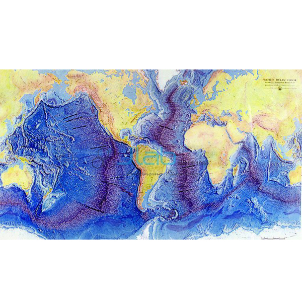
Ocean Floor Raised Relief Map (code EL-GE-7311) is a 660 x 990 mm raised relief map of the world that captures the geography of both the land and the ocean floor, used to teach sea-bed relief and plate tectonics in school and college geography rooms. Ridges, mountains, continental shelves, continental slopes, trenches and islands are depicted, and framing options are available. It is made by Jain Laboratory Instruments Pvt Ltd (JLab) at its works in Ambala, India.
Specifications
| Parameter | Detail |
|---|---|
| Type | Raised relief map |
| Coverage | The world — geography of the land and the ocean floor |
| Size | 660 x 990 mm |
| Features depicted | Ridges, mountains, continental shelves, continental slopes, trenches and islands |
| Framing | Framing options available — state your choice in the enquiry |
| Quality check | Each map is visually inspected before dispatch |
| Pack quantity | Each (sold individually) |
| Minimum order quantity | 10 units |
| Dispatch time | Usually 7–10 working days |
| Product code | EL-GE-7311 |
| Manufacturer | Jain Laboratory Instruments Pvt Ltd (JLab) — OEM |
| Country of origin | India (made in Ambala, Haryana) |
What Is the Ocean Floor Raised Relief Map Used For?
A flat wall map shows the oceans as plain blue; this map shows what lies beneath them. Students can follow a continental shelf out to the steeper continental slope, trace an ocean ridge, where new crust forms as plates move apart, and find the deep trenches, where one plate sinks beneath another. It supports the class 11 physical geography chapters on the relief of the ocean floor and on the distribution of oceans and continents, earth science lessons on sea-floor spreading, and introductory geology and oceanography courses in colleges.
Hang the map at a height the class can reach, or lay it on a large table for group work, and use it alongside a globe or atlas. Dust the surface with a soft, dry cloth and avoid pressing on the raised areas.
What to Specify When Ordering
- Framing — framed or unframed, since framing options are available.
- Quantity — the minimum order is 10 maps, for example one per geography room across a group of schools.
- Companion aids — the sea floor spreading activity model or the earth processes poster can go on the same enquiry.
- Delivery details — destination country and city or port, delivery terms and any tender reference.
Frequently Asked Questions
What does the map show?
The geography of the land and the ocean floor for the whole world, with ridges, mountains, continental shelves, continental slopes, trenches and islands in raised relief.
What size is it?
660 x 990 mm.
Can the map be supplied framed?
Yes, framing options are available. Say whether you want it framed when you ask for a quotation.
Which classes is it suited to?
Secondary school geography and earth science, particularly class 11 topics on ocean-floor relief and plate movement, and introductory geology or oceanography courses at college level.
How does it work with the Sea Floor Spreading Activity Model?
The map shows where ridges and trenches lie today, while the activity model lets students recreate the oceanic expansion that produced them, so the two explain both the pattern and the process.
What does an export quotation need?
Quantity, framing choice, destination country and port or city, delivery terms such as FOB or CIF, any packing or labelling instructions, and a tender reference where relevant.
Who makes the map?
Jain Laboratory Instruments Pvt Ltd, trading as JLab, produces it at its works in Ambala, Haryana, India, and sells it factory-direct.
OEM Manufacturer
JLab is the trading name of Jain Laboratory Instruments Pvt Ltd, a geography and science teaching equipment manufacturer in India, incorporated in 2017 and working from Hargolal Road, Ambala, Haryana. The relief map is produced at JLab’s own works rather than sourced from a trader, so schools, colleges, dealers and importers order from the manufacturer itself; every map is visually checked before dispatch, and repeat orders are supplied by the same team. JLab exports globally and serves buyers in all regions — Niger in West Africa, Mongolia in East Asia, Ethiopia in East Africa, New Zealand in Oceania and Mexico in North America are some examples. Tender details are on the JLab lab tenders page.
Related Earth Science Models and Maps
- Sea Floor Spreading Activity Model — recreates oceanic expansion and the creation of new lithosphere at mid-ocean ridges.
- Visualising Earth Processes Poster — the rock cycle, faulting and folding, earthquakes, volcanism, weathering and erosion.
- Earth Shakes — an earthquake activity modelling S waves, P waves and a strike-slip fault.
- Volcano Model — a hand-painted cutaway view of a volcano and its processes.
- Raised Relief Map of the Moon — the near and far sides of the Moon with lunar mission landing sites.
Browse the full Geology Equipment range or all Geography Lab Models.
Request a Quote
Quotes come direct from the manufacturer. Use the Add To Cart enquiry button on this page, or send the number of maps (minimum 10 units), whether you want them framed, and your delivery location through the contact page.
Last updated: 3 October 2026