
Predicting the Weather Poster Manufacturer,Supplier and Exporter in India
Product Code : EL-WE-7497
Jlab Export is a leading Predicting the Weather Poster Manufacturer,and suppliers in India
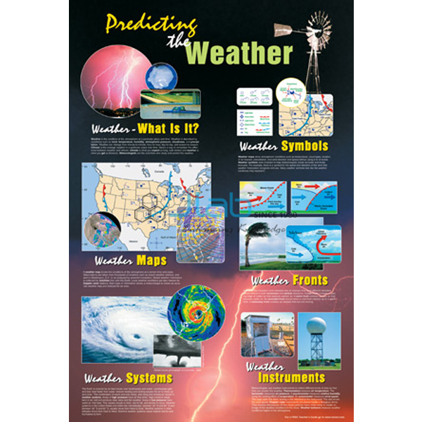
Predicting the Weather Poster (code EL-WE-7497) is a classroom wall poster that teaches students how to predict tomorrow’s weather. From it they learn to read a weather map, recognise weather symbols and describe a weather system, using the hurricane as the model, before forecasting their own local weather. An illustrated teacher’s guide is included. It is made by Jain Laboratory Instruments Pvt Ltd (JLab) at its works in Ambala, India.
Specifications
| Parameter | Detail |
|---|---|
| Type | Classroom poster on weather maps and forecasting |
| Topics covered | Reading a weather map; recognising weather symbols; decoding different types of weather maps; describing the characteristics of a weather system using the hurricane as a model |
| Class activity | Students go on to predict the local weather |
| Included | Illustrated teacher’s guide |
| Quality check | Each poster is visually inspected before dispatch |
| Pack quantity | Each (sold individually) |
| Minimum order quantity | 10 units |
| Dispatch time | Usually 7–10 working days |
| Product code | EL-WE-7497 |
| Manufacturer | Jain Laboratory Instruments Pvt Ltd (JLab) — OEM |
| Country of origin | India (made in Ambala, Haryana) |
What Is the Predicting the Weather Poster Used For?
Weather decides how people dress and plan their day, which makes forecasting an easy topic to start a geography lesson with. The poster walks students through reading a weather map — which typically shows lines of equal pressure, fronts and symbols for cloud, rain and wind — and through the different kinds of weather maps. A hurricane serves as the worked example of a weather system: a tropical cyclone with a calm, low-pressure eye surrounded by the strongest winds and spiral bands of rain. In the Bay of Bengal and Arabian Sea the same kind of storm is called a cyclone, which links the poster to Indian weather reports.
It suits the weather maps and symbols work in class 11 practical geography, middle-school units on weather and climate, and teacher-training courses. A common way to use it is to display it beside the school weather station, read the day’s map with the class, and ask students to forecast the next day and check the result. The teacher’s guide supports lesson planning.
What to Specify When Ordering
- Quantity — the minimum order is 10 posters; schools often order one per geography room plus spares.
- Size and finish — ask JLab to confirm the poster size and whether it is paper or laminated.
- Matching charts — weather symbol and weather instrument charts can be added to the same enquiry.
Frequently Asked Questions
What will students learn from this poster?
How to read a weather map, recognise weather symbols, decode different types of weather maps and describe a weather system, with the hurricane as the example. They can then try predicting the local weather.
Is a teacher’s guide included?
Yes. The poster comes with an illustrated teacher’s guide.
What size is the poster?
The size and finish are not given in this listing. Ask JLab for them when you request a quote.
Why does the poster use a hurricane as its model?
A hurricane shows the parts of a weather system very clearly — low pressure at the centre, an eye, a ring of strong winds and rain bands — so students can identify them and then apply the same reading to everyday weather maps.
Who manufactures this poster?
Jain Laboratory Instruments Pvt Ltd (JLab) makes it in Ambala, Haryana, India, and quotes for it directly.
OEM Manufacturer
JLab is the trading name of Jain Laboratory Instruments Pvt Ltd, a producer of geography lab equipment, charts and science teaching aids in India, incorporated in 2017 and based on Hargolal Road, Ambala, Haryana. The poster is produced at JLab’s own works, not resold from a trader, so schools, colleges, dealers and importers buy direct from the source, each poster is inspected before it is packed, and repeat orders are handled by the manufacturer. JLab exports worldwide and serves buyers in every region — for example Austria in Western Europe, Zambia in East Africa, the Czech Republic in Eastern Europe, Algeria in North Africa and Mongolia in East Asia. School tender details are on the JLab lab tenders page.
Weather Charts and Models
- Weather Map Symbols Chart — a chart of the symbols used on weather maps, in English only or English and Hindi combined.
- Weather Model — a three-dimensional weather map of a warm and a cold front in a developing cyclonic storm.
- Weather and Climate Poster — shows how weather and climate are related.
- Weather Instruments Chart — a laminated chart in English and Hindi combined.
- Weather Station — a wooden station for mounting the instruments whose readings feed a class forecast.
More items are in the Weather Equipment range and the wider Geography Lab Models range.
Request a Quote
Quotes come direct from the manufacturer. Use the Add To Cart enquiry button on this page, or send the quantity (minimum 10 units), any matching charts you need, and your delivery country and city through the contact page.
Last updated: 3 October 2026