Geographical Terms 3D Model Manufacturer,Supplier and Exporter in India

Product Code : EL-ERAM-4433
Jlab Export is a leading Geographical Terms 3D Model Manufacturer,and suppliers in India
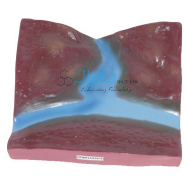
Geographical Terms 3D Model (code EL-ERAM-4433) is a 70 x 100 cm relief model showing ideal features of a landscape, so that students can see how particular geographical terms are formed and where each one sits. It is made of rigid PVC with a markable, washable surface on a hard backing, finished with an aluminium frame and hooks. JLab (Jain Laboratory Instruments Pvt Ltd) manufactures it in Ambala, India.
Specifications
| Parameter | Detail |
|---|---|
| Subject | Ideal landscape features illustrating the formation of geographical terms |
| Material | Rigid PVC |
| Surface | Markable and washable |
| Backing, frame and mounting | Hard backing, aluminium frame and hooks |
| Size | 70 x 100 cm |
| Quality check | Each model is visually inspected before dispatch |
| Pack quantity | Each (sold individually) |
| Minimum order quantity | 10 units |
| Dispatch time | Usually 7–10 working days |
| Product code | EL-ERAM-4433 |
| Manufacturer | Jain Laboratory Instruments Pvt Ltd (JLab) — OEM |
| Country of origin | India (made in Ambala, Haryana) |
What Is the Geographical Terms 3D Model Used For?
Many words in a geography syllabus — island, peninsula, isthmus, bay, strait, delta, plateau — describe a shape of land or water and its position relative to its neighbours. Definitions alone are easy to mix up; an idealised landscape that places the features side by side shows, for example, that a peninsula joins the mainland while an island does not. The model is used in middle-school map lessons and as a revision board in the geography lab, and its markable, washable surface lets students label features during a lesson and wipe the board clean afterwards.
Frequently Asked Questions
Which geographical terms does the model cover?
The listing describes ideal landscape features for the formation of particular geographical terms but does not name them. Ask JLab for the list before ordering if your syllabus requires specific terms.
What is it made of, and how big is it?
Rigid PVC with a markable, washable surface, a hard backing, an aluminium frame and hooks; it measures 70 x 100 cm.
Who makes the Geographical Terms 3D Model?
JLab builds it at its Ambala works and quotes for it as the manufacturer, not as a reseller.
OEM Manufacturer
Behind the model is Jain Laboratory Instruments Pvt Ltd, trading as JLab, a geography and science teaching equipment manufacturer incorporated in 2017 and located on Hargolal Road, Ambala, Haryana. It makes the model in its own works and sells it without a middleman to schools, colleges, distributors and importers, who come back to the same maker for repeat orders. JLab exports worldwide and ships to buyers in every region — for example Angola in Central Africa, Bangladesh in South Asia, Iraq in the Middle East, Romania in Eastern Europe and Namibia in Southern Africa.
Single-Landform Models
- Peninsula Model — a projecting area of land surrounded by water on three sides.
- Archipelago Model — a chain or cluster of islands.
- Island and Lagoon Model — an island and the enclosed water of an atoll.
- Bay Model — an area of sea water mostly surrounded by land.
- Physical Features of Earth Chart — a wall chart on landforms and water bodies.
See all of Educational Rock and Minerals and Rocks and Minerals.
Request a Quote
Quotations are issued by the manufacturer. Use Add To Cart, or send your quantity (minimum 10 units), destination and the terms you need covered through the contact page.
Last updated: 9 October 2026