
Geo Physical World Map Manufacturer,Supplier and Exporter in India
Product Code : EL-ME-7485
Jlab Export is a leading Geo Physical World Map Manufacturer,and suppliers in India
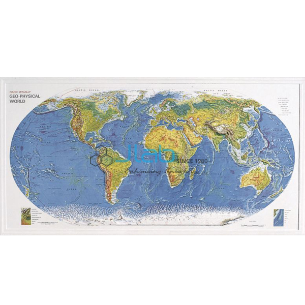
Geo Physical World Map (code EL-ME-7485) is a 3-D raised relief map of the world that highlights physical features while also showing countries, cities and oceans. The raised surface lets students see, and feel, where the great mountain ranges, plateaus and lowlands lie, so it is used in school and college geography rooms for lessons on the physical world. It is made by Jain Laboratory Instruments Pvt Ltd (JLab) at its works in Ambala, India.
Specifications
| Parameter | Detail |
|---|---|
| Type | 3-D raised relief world map |
| Highlights | Physical features |
| Also shows | Countries, cities and oceans |
| Quality check | Each map is visually inspected before dispatch |
| Pack quantity | Each (sold individually) |
| Minimum order quantity | 10 units |
| Dispatch time | Usually 7–10 working days |
| Product code | EL-ME-7485 |
| Manufacturer | Jain Laboratory Instruments Pvt Ltd (JLab) — OEM |
| Country of origin | India (made in Ambala, Haryana) |
What Is the Geo Physical World Map Used For?
On a flat physical map, height is shown only by colour and shading, and students can find it hard to connect the brown and green bands with real mountains and plains. A raised relief map puts the relief into the surface itself. Students can run a finger along a mountain chain, compare the height of one continent’s landforms with another’s, and then locate the countries, cities and oceans shown on the same map — linking physical geography to the political map they already know. Raised relief maps normally exaggerate height so that the relief is easy to see, which is worth pointing out when students compare them with true cross-sections.
It suits school geography lessons on the physical features of the continents, revision of map-location work, and introductory physical geography at college. Keep it where the raised surface will not be pressed or crushed.
What to Specify When Ordering
- Quantity — the minimum order is 10 maps.
- Size and mounting — the listing does not state the dimensions or how the map is hung, so ask for both, along with the packed size for freight.
- Companion items — political wall maps, globes and relief models (linked below) can be quoted together.
Frequently Asked Questions
What does the Geo Physical World Map show?
Physical features of the world in 3-D raised relief, together with countries, cities and oceans.
What size is the map?
The listing does not give its size, scale or material. Ask JLab for these details with your quotation.
How is it different from the Ocean Floor Raised Relief Map?
Both are raised relief maps of the world. The ocean floor map is listed as capturing the geography of the land and of the ocean floor; this map highlights physical features and also shows countries, cities and oceans.
Who makes this map?
Jain Laboratory Instruments Pvt Ltd (JLab) manufactures it at its works in Ambala, Haryana, India.
OEM Manufacturer
JLab is the trading name of Jain Laboratory Instruments Pvt Ltd, a maker of geography, science and laboratory teaching equipment in India, incorporated in 2017 and located on Hargolal Road, Ambala, Haryana. The Geo Physical World Map is produced in JLab’s own works rather than bought in from a trader, so schools, colleges, dealers and importers buy it straight from the manufacturer; each map is inspected by eye before it is packed, and repeat orders are handled in-house. JLab exports worldwide and serves buyers in every region, for example the Maldives in South Asia, Slovenia in Southern Europe, Sierra Leone in West Africa, Laos in Southeast Asia and Finland in Northern Europe. See the JLab lab tenders page for tender supply.
Related Maps, Globes and Relief Models
- Ocean Floor Raised Relief Map — a raised relief world map of both land and ocean-floor geography.
- Map Of World Political — a giant-size laminated political wall map with plastic rollers.
- Physical Globe — a physical globe offered in several sizes.
- 3D Relief Models- I — relief wall models in rigid PVC with a markable, washable surface.
- Topographic Modeling and Mapping Activity Model — a map-work activity with an illustrated teacher’s and student’s guide.
See the full Mapping Equipment range or all Geography Lab Models.
Request a Quote
Quotes come direct from the manufacturer. Use the Add To Cart enquiry button on this page, or send the number of maps (minimum 10 units), your destination country and port or city, delivery terms such as FOB or CIF, and any tender reference through the contact page.
Last updated: 3 October 2026