Karnataka Political Map Chart Manufacturer,Supplier and Exporter in India
Product Code : EL-SMP-3313
Jlab Export is a leading Karnataka Political Map Chart Manufacturer,and suppliers in India
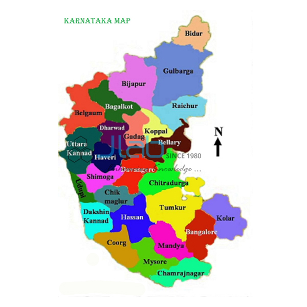
Karnataka Political Map Chart (code EL-SMP-3313) is a 70 x 100 cm wall map of Karnataka that shows the latest boundaries, capital cities and important towns, and other political features, for social science and geography classrooms. It is printed in multicolour on 80 gsm map litho paper, laminated on both sides with hot-seal polyester film, and fitted with plastic rollers; it is offered in the state’s own language or in English. It is made by Jain Laboratory Instruments Pvt Ltd (JLab) at its works in Ambala, India.
Specifications
| Parameter | Detail |
|---|---|
| Coverage | Karnataka, political map |
| Map details | Latest boundaries; capital cities and important towns; political features |
| Size | 70 x 100 cm |
| Paper and printing | 80 gsm map litho paper, printed in multicolour |
| Lamination | Hot-seal polyester film on both sides |
| Rollers | Plastic rollers fitted at top and bottom |
| Language | The state’s own language, or English only |
| Quality check | Each chart is visually inspected before dispatch |
| Pack quantity | Each (sold individually) |
| Minimum order quantity | 10 units |
| Dispatch time | Usually 7–10 working days |
| Product code | EL-SMP-3313 |
| Manufacturer | Jain Laboratory Instruments Pvt Ltd (JLab) — OEM |
| Country of origin | India (made in Ambala, Haryana) |
What Is the Karnataka Political Map Used For?
Karnataka has six neighbours — Goa, Maharashtra, Telangana, Andhra Pradesh, Tamil Nadu and Kerala — and a coastline on the Arabian Sea, and a political map is the clearest way for pupils to fix those relationships. Students use it to find the capital, Bengaluru, and to place important towns across the regions of the state: Mysuru in the south, Mangaluru and Udupi on the coast, Shivamogga in the Malnad, Hubballi-Dharwad and Belagavi in the north-west, and Kalaburagi, Vijayapura and Ballari in the north. Belagavi is also where the state legislature holds its winter session, in the Suvarna Vidhana Soudha. These names are lesson examples; the listing does not itemise the towns or district lines printed, so confirm a specific place with JLab if your syllabus requires it.
Karnataka schools use the state-language edition or the English edition for home-state social science; elsewhere it supports regional geography of southern India and map questions in competitive-exam practice. The double-sided lamination can be wiped with a damp cloth; mark places with a pointer rather than pins, and keep the map rolled, not folded, when it is off the wall.
What to Specify When Ordering
- Edition — the state’s own language (Kannada is the official language) or English only.
- Quantity — 10 units minimum.
- Neighbouring maps — Kerala, Tamil Nadu, Andhra Pradesh and Telangana charts for a southern India set.
- Delivery — delivery town or export port, FOB or CIF terms, and the tender reference if applicable.
Frequently Asked Questions
Is a Kannada edition available?
The chart is offered in the state’s own language or in English only. Kannada is Karnataka’s official language; confirm the language with JLab when you ask for a quotation.
What information does the map carry?
The latest boundaries, capital cities and important towns, and political features, printed in several colours. Individual towns are not listed, so ask JLab about any place you need shown.
How big is the chart, and what is it made of?
It is 70 x 100 cm, printed on 80 gsm map litho paper, laminated with hot-seal polyester film on both sides, and fitted with plastic rollers at top and bottom.
Which states border Karnataka?
Six: Goa, Maharashtra, Telangana, Andhra Pradesh, Tamil Nadu and Kerala, with the Arabian Sea on the west. A political map like this one lets pupils trace each boundary.
Who manufactures this map?
Jain Laboratory Instruments Pvt Ltd (JLab) makes it at its works in Ambala, Haryana, and supplies it directly as the manufacturer.
OEM Manufacturer
JLab is the trading name of Jain Laboratory Instruments Pvt Ltd, a manufacturer in India of state and world wall maps, educational charts and school lab equipment, incorporated in 2017 and based on Hargolal Road, Ambala, Haryana. The map is produced in the company’s own works rather than bought from traders, so schools, colleges, dealers and importers buy straight from the maker, every chart is checked by eye before dispatch, and repeat orders are handled by the manufacturer. JLab exports worldwide and serves buyers in every region, for instance Bolivia in South America, Japan in East Asia, Uganda in East Africa, Hungary in Eastern Europe and Lesotho in Southern Africa. For tenders, see the JLab lab tenders page.
Southern India State Maps
- Kerala Political Map Chart — the south-western neighbour, in the same 70 x 100 cm format.
- Tamil Nadu Chart — the south-eastern neighbour, with latest boundaries and important towns.
- Andhra Pradesh Political Chart — the eastern neighbour, laminated on both sides.
- Telangana Political Chart — the north-eastern neighbour, in English only or the regional language only.
- Political Chart — a laminated 70 x 100 cm political chart in English only or Hindi only.
Find the other states in State Maps Political, or browse all Charts.
Request a Quote
Quotations come direct from the manufacturer. Use Add To Cart on this page or the contact page, and include the number of maps (minimum 10 units), the language edition, and the delivery town or port.
Last updated: 3 October 2026