Kerala Political Map Chart Manufacturer,Supplier and Exporter in India
Product Code : EL-SMP-3314
Jlab Export is a leading Kerala Political Map Chart Manufacturer,and suppliers in India
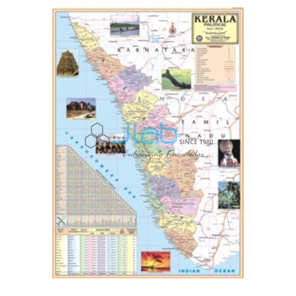
Kerala Political Map Chart (code EL-SMP-3314) is a 70 x 100 cm political wall map of Kerala listed with the latest boundaries, capital cities, important towns and political features, for teaching the state’s geography in schools and colleges. The multicolour print on 80 gsm map litho paper is sealed in polyester film on both sides and hangs from plastic rollers. JLab (Jain Laboratory Instruments Pvt Ltd, Ambala, India) supplies it to schools, colleges and dealers.
Specifications
| Parameter | Detail |
|---|---|
| Map | Kerala, political |
| Content listed | Latest boundaries; capital cities and important towns; political features |
| Dimensions | 70 x 100 cm |
| Multicolour on 80 gsm map litho paper | |
| Lamination | Hot-seal polyester film, both sides |
| Rollers | Plastic, at top and bottom |
| Language | The state’s own language, or English only |
| Quality check | Each chart is visually inspected before dispatch |
| Pack quantity | Each (sold individually) |
| Minimum order quantity | 10 units |
| Dispatch time | Usually 7–10 working days |
| Product code | EL-SMP-3314 |
| Supplied by | Jain Laboratory Instruments Pvt Ltd (JLab), Ambala, India |
What Is the Kerala Political Map Used For?
Kerala is a long, narrow state lying between the Arabian Sea on the west and the Western Ghats on the east, with Karnataka to the north and Tamil Nadu to the east and south. A political map lets pupils see how the state stretches along the coast and clears up a detail that surprises many learners: Mahe, on the Kerala coast, belongs to the union territory of Puducherry. Students use the chart to find the capital, Thiruvananthapuram, in the far south and to work northwards through important towns such as Kollam, Alappuzha, Kottayam, Kochi, Thrissur, Palakkad, Kozhikode and Kannur. These are lesson examples; the listing does not name every town marked, so check with JLab before ordering if your syllabus needs a specific place.
Kerala schools use the state-language or English edition for home-state social science, while schools and colleges in other states hang it beside neighbouring maps for the regional geography of southern India and for map practice ahead of competitive examinations. The polyester film keeps humid coastal air off the paper and wipes clean with a damp cloth; use a pointer rather than pins, and roll the chart from the bottom roller when it goes into storage.
What to Specify When Ordering
- Edition — the state’s own language (Malayalam is Kerala’s official language) or English only.
- Quantity — minimum order 10 units.
- Neighbouring maps — Karnataka and Tamil Nadu charts complete the south-western corner of India.
- Delivery — delivery town or export port, FOB or CIF terms, and tender reference if relevant.
Frequently Asked Questions
Can I get the Kerala map in Malayalam?
The chart is offered in the state’s own language or in English only, and Malayalam is Kerala’s official language. Confirm the language edition with JLab when you enquire.
What does the chart show?
Kerala’s latest boundaries, its capital cities and important towns, and other political features, in multicolour print. Towns are not itemised in the listing, so ask about any particular place.
What are the dimensions and finish?
It is 70 x 100 cm on 80 gsm map litho paper, laminated with hot-seal polyester film on both sides and fitted with plastic rollers at top and bottom.
Is Mahe part of Kerala?
No. Mahe is a small coastal enclave that belongs to the union territory of Puducherry, although Kerala surrounds it on land — a common map-reading question.
What should an export enquiry include?
Quantity and language edition, the destination country and port or city, preferred terms such as FOB or CIF, any packing or labelling instructions, and a tender reference if there is one.
Who supplies the Kerala Political Map Chart?
Jain Laboratory Instruments Pvt Ltd, trading as JLab, of Ambala, Haryana, supplies it and quotes directly.
Supplier
JLab is the trading name of Jain Laboratory Instruments Pvt Ltd, a school equipment and teaching-aid company incorporated in 2017 and based on Hargolal Road, Ambala, Haryana. Printed state maps such as this one are resold by JLab together with the laboratory items in its own range, so a school or dealer can cover maps and equipment in one order, and each map is inspected by eye before dispatch. JLab exports worldwide and ships to buyers in every region — including Ecuador in South America, Ethiopia in East Africa, Moldova in Eastern Europe, Chad in Central Africa and Qatar in the Middle East. Tender buyers can see the JLab lab tenders page.
Neighbouring and Related Maps
- Karnataka Political Map Chart — the northern neighbour, a 70 x 100 cm state wall map.
- Tamil Nadu Chart — the eastern and southern neighbour, in the same 70 x 100 cm size.
- Andhra Pradesh Political Chart — another southern state political map.
- India Chart — a laminated 70 x 100 cm wall map of India in English only or Hindi only.
- Political Chart — a laminated 70 x 100 cm political map chart.
- Political Globe — a globe showing the political boundaries of the world’s countries.
All state maps are in State Maps Political; see also the complete Charts catalogue.
Request a Quote
JLab answers enquiries directly. Use the Add To Cart button on this page or the contact page, stating the quantity (minimum 10 units), the language edition and the delivery location.
Last updated: 4 October 2026