
Rajasthan Political Map Chart Manufacturer,Supplier and Exporter in India
Product Code : EL-SMP-3316
Jlab Export is a leading Rajasthan Political Map Chart Manufacturer,and suppliers in India
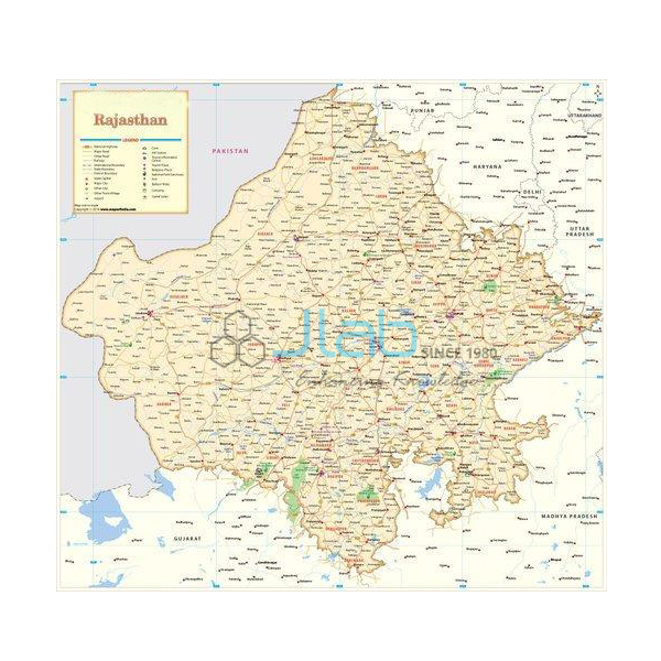
Rajasthan Political Map Chart (code EL-SMP-3316) is a multicolour 70 x 100 cm classroom wall map setting out Rajasthan’s latest boundaries, capital cities and important towns for geography and social studies teaching. It is printed on 80 gsm map litho paper, sealed in hot-seal polyester film on both sides and fitted with rollers at top and bottom. JLab (Jain Laboratory Instruments Pvt Ltd, Ambala, India) supplies it to schools, colleges and dealers.
Specifications
| Parameter | Detail |
|---|---|
| Coverage | Rajasthan state, political map |
| Map content | Latest boundaries; capital cities and important towns; political features |
| Dimensions | 70 x 100 cm |
| Paper and print | 80 gsm map litho paper, printed in multicolour |
| Protective finish | Hot-seal polyester film lamination, both sides |
| Hanging | Plastic rollers fitted at top and bottom |
| Language options | Own state language, or English only |
| Quality check | Each chart is visually inspected before dispatch |
| Pack quantity | Each (sold individually) |
| Minimum order quantity | 10 units |
| Dispatch time | Usually 7–10 working days |
| Product code | EL-SMP-3316 |
| Supplied by | Jain Laboratory Instruments Pvt Ltd (JLab), Ambala, India |
What Is the Rajasthan Political Map Used For?
Rajasthan stretches across much of north-western India, and a political map helps pupils see how its towns and boundaries are arranged. In home-state lessons students locate Jaipur, the capital, pick out important towns such as Jodhpur, Udaipur, Bikaner, Ajmer and Kota, follow the international border with Pakistan on the west, and name the neighbouring states — Punjab, Haryana, Uttar Pradesh, Madhya Pradesh and Gujarat. Outside Rajasthan, schools and colleges hang the chart in the geography laboratory beside other state maps for the regional study of India, and it is a handy reference for map-based general-knowledge practice. These place names are lesson examples; the listing does not name every town marked.
Use a pointer rather than drawing pins, which would puncture the lamination and let moisture reach the paper. In dusty rooms, wipe the film from time to time with a damp cloth, and for storage roll the chart from the bottom roller and keep it in a dry cupboard. The product photograph may not show the printed chart itself, so ask JLab for a current image of the edition you are quoted.
What to Specify When Ordering
- Language edition — the state’s own language or English only, for each chart.
- Number of charts — at least 10 units per order.
- Companion maps — neighbouring-state charts, an India map or a world political map can be quoted together.
- Tender or delivery details — tender reference if applicable, and the delivery town or export destination.
Frequently Asked Questions
Which boundaries and places does the Rajasthan map show?
The state’s latest boundaries, its capital cities and important towns, and other political features, printed in several colours. The listing does not name every town, so ask JLab before ordering if your syllabus needs a particular place.
What are the dimensions and material of the chart?
It is 70 x 100 cm, printed on 80 gsm map litho paper and sealed on both faces with hot-seal polyester film, with plastic rollers along the top and bottom edges.
Is a Hindi edition available?
The chart is offered in the state’s own language or in English only. Hindi is the official language of Rajasthan; ask JLab to confirm the language of the state-language edition with your quotation.
Does the map show the Aravalli Range or the Thar Desert?
It is listed as a political map — boundaries, capital, towns and political features. Relief and desert areas are not part of its specification, so check with JLab if you need them shown.
Can I pin labels or notes onto the map?
Avoid pins and tacks, because they pierce the lamination. Use a pointer, or put removable notes on the wall or board around the chart.
How many charts must I order, and how soon are they dispatched?
The minimum is 10 units, each a single chart. Dispatch usually follows within 7–10 working days once every chart has passed a visual inspection; export transit is extra and depends on the route.
Who supplies the Rajasthan Political Map Chart?
JLab — Jain Laboratory Instruments Pvt Ltd of Ambala, Haryana, India — supplies it and quotes directly.
Supplier
JLab is the trading name of Jain Laboratory Instruments Pvt Ltd, a school laboratory and classroom-equipment supplier incorporated in 2017 and based on Hargolal Road, Ambala, Haryana. JLab resells printed wall maps like this one together with the lab equipment in its own range, so schools, dealers and importers can bring maps and equipment together on one order; every chart is visually checked before dispatch. The company holds GSTIN 06AADCJ9848D1ZE and Importer-Exporter Code 3317504552. It exports worldwide and ships to buyers in every region — for example Nepal in South Asia, El Salvador in Central America and the Caribbean, Samoa in Oceania, Singapore in Southeast Asia and Bolivia in South America. Tender buyers can refer to the JLab lab tenders page.
Maps of Neighbouring States and Wider Regions
- Punjab Political Map Chart — Rajasthan’s northern neighbour, in the same 70 x 100 cm size.
- Haryana Map Chart — the north-eastern neighbour, a 70 x 100 cm political wall map.
- Uttar Pradesh Political Map Chart — a 70 x 100 cm laminated wall map of the neighbouring state to the east.
- India Chart — a laminated 70 x 100 cm wall map of India in English only or Hindi only.
- Political Chart — a laminated 70 x 100 cm political map chart.
- Map Of World Political — a giant-size laminated world political map in English.
See every state in State Maps Political or browse all Charts.
Request a Quote
Send your enquiry straight to JLab with the Add To Cart button on this page or through the contact page, listing the quantity (minimum 10 units), the language edition and the delivery destination.
Last updated: 4 October 2026