Structure of Earth Chart Manufacturer,Supplier and Exporter in India
Product Code : EL-COG-3109
Jlab Export is a leading Structure of Earth Chart Manufacturer,and suppliers in India
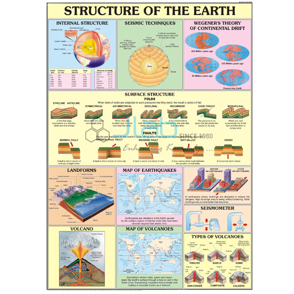
Structure of Earth Chart (code EL-COG-3109) is a 70 x 100 cm wall chart for teaching what lies beneath our feet — the layered interior of the Earth, from the thin crust through the mantle to the core — in school geography rooms and introductory earth science classes. It is available in English only, or laminated with English and Hindi combined. JLab (Jain Laboratory Instruments Pvt Ltd, Ambala, India) supplies it to schools, colleges and dealers.
Specifications
| Parameter | Detail |
|---|---|
| Topic | Structure (interior) of the Earth |
| Chart size | 70 x 100 cm |
| Versions | English only; or English and Hindi combined, laminated |
| Labels and diagrams | Not itemised in the listing; a preview image can be requested |
| Quality check | Each chart is visually inspected before dispatch |
| Pack quantity | Each (sold individually) |
| Minimum order quantity | 10 units |
| Dispatch time | Usually 7–10 working days |
| Product code | EL-COG-3109 |
| Supplied by | Jain Laboratory Instruments Pvt Ltd (JLab), Ambala, India |
What Is the Structure of Earth Chart Used For?
No one can drill through the planet, so the Earth’s interior is taught from a cross-section, and a wall chart keeps that section in front of the class. Students learn the three main layers: the crust, a thin rocky shell whose continental part is rich in silica and alumina (sial) and whose ocean floor is mainly silica and magnesium (sima); the mantle, whose upper part includes the partly molten asthenosphere that feeds magma to volcanoes; and the core, made mostly of nickel and iron (nife), with a liquid outer core around a solid inner core. Much of this knowledge comes from the way earthquake waves travel through the Earth.
The chart is used in middle-school geography, in class 11 physical geography where the interior of the Earth is a chapter of its own, and as a lead-in to earthquakes, volcanoes and rocks. Ask for a preview image if your syllabus uses particular layer names or boundaries.
What to Specify When Ordering
- Version — English only, or English and Hindi combined (laminated).
- Quantity — minimum 10 units across your order.
- Three-dimensional aids — an Earth layers model or an Earth’s interior 3D model, if students should handle the layers as well as read about them.
Frequently Asked Questions
Which layers of the Earth does the chart show?
The listing does not itemise the labels. The topic is the Earth’s structure — crust, mantle and core — and JLab can provide a preview image so you can check the detail.
How big is the chart?
It is 70 x 100 cm.
Which languages are offered?
English only, or English and Hindi combined on one laminated chart.
Is a 3D model a better choice?
They do different jobs: the chart gives the whole class a labelled section to refer to, while a layers model lets students see the layers in three dimensions, and the two can be used together.
Who supplies the Structure of Earth Chart?
JLab, the trading name of Jain Laboratory Instruments Pvt Ltd, Ambala, Haryana, India, which quotes for it directly.
Supplier
Jain Laboratory Instruments Pvt Ltd, trading as JLab, was incorporated in 2017 and is based on Hargolal Road, Ambala, Haryana. It supplies printed geography charts like this one as part of a catalogue that also covers its own laboratory and teaching equipment, so an earth science room can be furnished from one source. Every chart is looked over before dispatch. JLab exports worldwide and serves buyers in every region, for example Trinidad and Tobago in Central America and the Caribbean, Mongolia in East Asia, Chad in Central Africa, Malawi in East Africa and Brazil in South America. Tender details are on the JLab lab tenders page.
Earth Science Charts and Models
- The Earths Interior 3D Model — rigid PVC with a markable, washable surface, hard backing, aluminium frame and hooks.
- Earth Layers Model — a stand-mounted model with each layer sectioned in a different colour.
- Volcano Chart — how molten rock reaches the surface and builds volcanic landforms.
- Rocks and Minerals Chart — the same size, on what rocks are made of and how the main rock types form.
- Earth and Its Motion Chart — the same series, on rotation and revolution.
Find more titles under Charts on Geography or in the Charts range.
Request a Quote
To get a quotation from JLab, use the Add To Cart enquiry button or the contact page, giving the version, the number of charts (minimum 10 units) and the delivery address or port.
Last updated: 4 October 2026