Surveying Chart Manufacturer,Supplier and Exporter in India
Product Code : EL-COG-3115
Jlab Export is a leading Surveying Chart Manufacturer,and suppliers in India
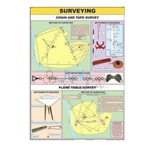
Surveying Chart (code EL-COG-3115) is a 70 x 100 cm wall chart for introducing land surveying — how distances, directions and heights are measured on the ground and turned into maps and plans — in practical geography rooms, colleges and surveying classes. It is listed in English only and as a laminated chart with English and Hindi combined. JLab (Jain Laboratory Instruments Pvt Ltd, Ambala, India) supplies it to schools, colleges and dealers.
Specifications
| Parameter | Detail |
|---|---|
| Subject | Surveying (practical geography) |
| Size | 70 x 100 cm |
| Versions | English only; or English and Hindi combined, laminated |
| Methods and instruments shown | Not itemised in the listing; ask for a preview image |
| Quality check | Each chart is visually inspected before dispatch |
| Pack quantity | Each (sold individually) |
| Minimum order quantity | 10 units |
| Dispatch time | Usually 7–10 working days |
| Product code | EL-COG-3115 |
| Supplied by | Jain Laboratory Instruments Pvt Ltd (JLab), Ambala, India |
What Is the Surveying Chart Used For?
Surveying is the practical side of map-making: measuring distances, directions or angles, and heights on the ground so that an accurate map or plan can be drawn. Practical geography courses usually teach several methods in turn — the chain and tape survey for measuring distances and offsets, the prismatic compass survey for bearings, the plane table survey in which the map is drawn in the field, and levelling with a dumpy level to find relative heights and contours, with the theodolite introduced for precise angles. A chart in the room gives students a reference for these methods before they go outdoors.
It suits senior-secondary and college practical geography, introductory civil engineering surveying and surveyor courses at ITIs. Because the listing does not say which methods are drawn, request a preview image if the chart must cover a specific practical.
What to Specify When Ordering
- Version — English only, or laminated English and Hindi combined.
- Quantity — minimum 10 units.
- Field equipment — a plane table, prismatic compass or survey chain can be added to the same enquiry for the outdoor practical.
Frequently Asked Questions
Which survey methods does the Surveying Chart show?
The listing does not itemise them. Ask JLab for a preview image so you can check it against the practicals in your syllabus.
What size and languages are available?
The chart is 70 x 100 cm, in English only or in a laminated English and Hindi combined version.
Does the chart replace survey instruments?
No. It explains the methods; the practical itself needs instruments such as a plane table, prismatic compass, chain and tape, which are separate listings linked below.
Who supplies this chart?
JLab, the trading name of Jain Laboratory Instruments Pvt Ltd, Ambala, Haryana, India, supplies it and quotes directly.
Supplier
JLab is the trading name of Jain Laboratory Instruments Pvt Ltd, incorporated in 2017 and located on Hargolal Road, Ambala, Haryana. It supplies practical geography charts such as this one alongside the laboratory equipment in its own range, so a department can buy charts and field equipment on one order, and each chart is visually inspected before dispatch. JLab exports worldwide and ships to buyers in every region — for example Japan in East Asia, France in Western Europe, Cambodia in Southeast Asia, Malta in Southern Europe and Uganda in East Africa. Tender information is on the JLab lab tenders page.
Survey Equipment and Map-Reading Charts
- Plane Table — a flat, solid surface for drawing field charts, drawings and maps during a survey.
- Prismatic Compass — a compass with a magnetised needle for taking bearings.
- Survey Chain — the type of chain used by surveyors to measure distances.
- Hill Features, Contours and Map Setting Chart — how relief is shown with contours and how a map is set.
- Conventional Signs Chart — the same size, on the signs and symbols used on maps.
More titles are in Charts on Geography and Charts.
Request a Quote
JLab sends quotations directly. Use the Add To Cart enquiry button or the contact page, with the version, the number of charts (minimum 10 units), any survey instruments you need and the delivery destination.
Last updated: 4 October 2026